Thursday, June 26, 2014

Big Green Mountain


The Great Wall of Big Green Mountain

My first trip to Panthertown Valley was just a random exploration.  I had no specific destination because I didn't know how to get anywhere!  (If you haven't read that story and are interested it's at:

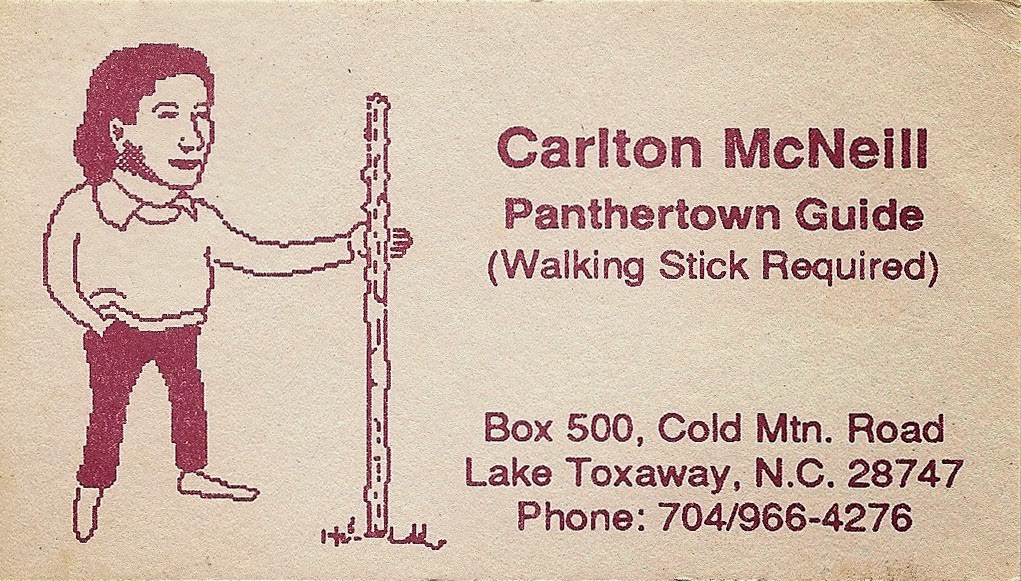
But on that first trip I met Carlton McNeill, and he started the process of orienting me.  He took my topo map and sketched in a few trails.  He showed me the route over Big Green Mountain, so for my next visit that was my goal.

I came into the Valley by the western entrance, stopping of course at Salt Rock to admire one of the best views in all of Panthertown.  I headed on down the hill, watching the right side of the road for the shortcut trail Carlton told me about.  After a couple of false starts I found it & followed it down to the Deep Gap Trail.  A left turn onto the Granny Burrrell Falls Trail soon led to the crossing of Panthertown Creek and the Great Wall Trail.
(I'm getting these trail names from the current "official" Panthertown Valley map, at that time none of the trails
were named or marked.  Here's a link to the PDF map:

I took off my boots, waded across the creek and headed out the Great Wall Trail. Stopped to look around the big campsite with the A-frame shelter, and a little farther down found the little spur trail that goes to the base of The Wall.  I don't think I ever passed by without taking the time to walk that short trail.  I loved the way it wound through the ferns, and of course the base of the Great Wall is amazing!

 Fern Trail

 The Great Wall

After some rambling around the boulder strewn base of the cliff I went back to the main trail and went on my way.  Next I came to the big ravine where the trail turns left & starts up the mountain.  Right at that point I stepped in a patch of mud.  Not big or deep, just a little spot of sticky black mud.  When I lifted my foot there was a loud "slurping" sound and the sole of my right hiking boot peeled almost completely off!  Turns out it was only sewed in place around the toe, and the rest was just glued on.  The soaking those boots got on my previous trip had evidently softened the glue, and now 3/4 of the sole was flapping in the breeze.  Surprise!

My first thought was that not only did this bring to a halt what had so far been a really enjoyable hike, it was going to be interesting getting back out the way I had come.  I may cussed a little (bad habit!).  I sat down to asses the situation, and rummaged around in my day-pack.  Luckily I had a piece of nylon cord that was just what I needed.  I was able to wind and twist and tie it around my boot til the sole felt fairly secure.  I tried walking around a little bit.  "Not bad!  I think I can make it back out with this!"  Walked around a little more, and the inevitable next thought: "Not bad at all!  And I really hate to turn back now..."  Am I really that dumb?  You should know the answer to that by now!

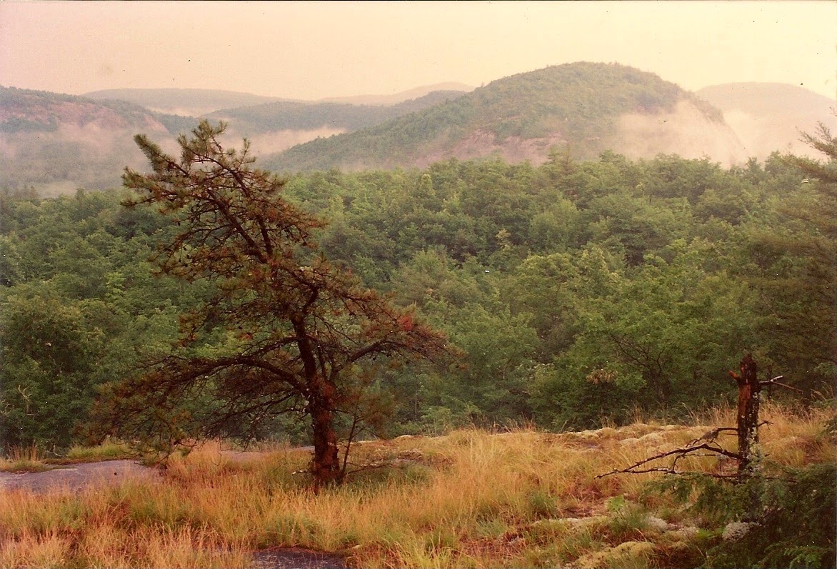
So I started up the mountain, telling myself what a foolish idea that was!  The trail is steep but beautiful.  It goes up a huge ravine in the mountainside, which I took the liberty of naming The Big Green Ravine.  A great place, and my boot was still together!  I finally came up to the Big Green Trail, and followed it up the ridge to the top of Big Green Mt.  I found the top of the cliffs and settled myself down for lunch and contemplation.  I still had a long path to get back out, but I wasn't worried.  It was such a beautiful spot, and I was just thankful to have reached my goal.

 View from Big Green Mt.


 Cliff-top on Big Green

After a relaxing stay it was time to make my way down.  I re-tied the cord holding my boot together and started out.  I followed the Big Green Trail to its intersection with the Mac's Gap Trail, & took a left on it.  As I was going down from Mac's Gap I ran into Carlton beside the trail picking blackberries.  Of course I had to stop & talk!  He said it was a slow summer for berries, he'd only picked 45 gallons so far.  (Every time I saw him during blackberry or blueberry season he'd tell me how many gallons he'd picked.  I don't know what he did with them all, I think he gave them away!)  
He was shaking his head at my tied-together boot, but when I told him where all I'd been he seemed to think I wasn't totally hopeless as a hiker.  We talked some more about scheduling a hike together, which sounded fine to me!

I made my way from there through Pine Valley and back up to Salt Rock without further incident.  Altogether an enjoyable and satisfying hike!  I did have to retire those boots, but I made sure the next pair were sewed all the way around the sole. 


Friday, June 20, 2014

To the Batcave

This was around 1975, so I was in my early 20s – ready for most anything.
A friend, who I will call The Instigator, approached me and a couple of like minded (crazy) friends with an idea for an adventure: “Let's go up to the Batcave!”

Always the responsible one, I replied: “We can't do that, I know where the trail starts, but it's covered up with No Trespassing signs!”

Oh, it'll be OK. I went up there last week and nothing happened. It's awesome! There's a big cave, and a bunch of cliffs. I want to go back up with ropes and do some rappelling.”

Well, that sounds like an adventure all right, lets go!”

The Instigator got his rope and the rest of us grabbed some flashlights(!) and the 4 of us headed out. We parked on the side of the road, walked around the No Trespassing signs, and followed the trail up the mountain. It was steep and rugged – just the way we liked it. The cave itself is in the line of cliffs that run along the gorge, so when we got up that far we were surrounded by rock faces and boulders. Beautiful!

We found the cave entrance easily, and went right in. I'd never seen a cave around here that big! A description I found online says this:
One of Bat Cave’s coolest features (pun intended) is its natural air conditioning: a cool moist draft constantly pours out of vents on the side of the large cave. Bat Cave is the largest known granite fissure cave in North America. The main chamber is a dark cathedral more than 300 feet long and approximately 85 feet high.”

We wandered around just checking it all out. And yes there were bats. Lots of bats! It was eerie! In several places around the sides there were cracks or holes that were just big enough to crawl though, but were too scary looking for any of us to attempt.

After we finished exploring we went back outside to where the cliffs were. My friend set up his rope on a 50 footer and was rappelling down in big swooping jumps. Having nearly gotten myself killed the year before in an attempted rappel off the side of Eagle Rock I was content to watch.

So I was standing there minding my own business when I heard a noise behind me. I turned around in time to see a man pop out of a hole in the ground, followed by two more, all with helmets and headlamps. Spelunkers! We got to talking, and one of them asked if we'd like a tour of the caves. Alrighty then!

So we went back into the main cave and he went to one of the cracks in the wall and crawled right in. We followed with our plastic flashlights and entered a whole new world. Since it's a fissure cave there were no more big open spaces, just cracks in the rock. There were passages leading off to the left & right, up & down. I felt like an ant crawling in a rockpile! It was a maze, and I soon realized that if I got separated from the group I wouldn't have a clue how to get back out.

A lot of places were a tight squeeze, including one spot where you had to lie on your back and wriggle under a huge slab of rock. It was so tight that even with my 32” waist I had to reach down & pull my belt buckle loose from the rock. I was on the verge of claustrophobia there, it felt like the weight of the whole mountain was pushing down on me, and one tiny movement of the rock would cut me in half! One of my friends who was just a little heavier got stuck, and it took one of us pulling his arms while another pushed his feet from behind to get him through.

The passages had holes in the floor, you had better watch your step! At one hole a couple of feet wide we stopped to see if we could tell how deep it was. All our lights combined showed only blackness. We tried tossing rocks down and listening to them bouncing off the sides. The sound faded away, and we never could hear it hit bottom...

Then we started climbing. It wasn't vertical enough to need ropes & gear, but dang nearly! I was a pretty good boulder scrambler, but this was as difficult as any I ever did. And did I mention most of the rock was wet? And we were in pitch blackness with our Kmart flashlights? One spot was an inclined rock over 50 feet long at a 45 degree angle. You needed both hands to climb, so we took turns holding a light for the person climbing. I made it about halfway up and got to a real sketchy spot. I barely had a foot-hold and was searching desperately for a hand-hold before I slipped. Right then somebody yelled: “I need some light over here!” My trusty light holder switched his beam to the other guy, leaving me in total darkness! I may have cussed some. I needed my light back NOW!

I'm not sure how far we went, but it was a long way. I do know I was relieved when we crawled up out of a hole into the sunlight again! We had to hike down about a quarter mile of steep mountainside to get back to the main cave again.

Whew, what an adventure! We went back down the trail tired but pleased with ourselves and what we had done. But when we got nearly to the bottom of the trail we looked through the trees and saw a sheriff’s car sitting next to ours. That wasn't part of the plan! We didn't want to come popping out of the trailhead with all the No Trespassing signs, so we bushwhacked away to the side til we were out of sight and then came walking up the road looking all sweet and innocent. Of course he knew where we had been, and proceeded to tell us so, along with a long lecture on Trespassing and arrest and prosecution and punishment. Mixed in with questions and checking of IDs and generally making us very uncomfortable for about 20 minutes. And the he let us go and drove away. Like I said, Whew!

The current status of the Batcave as I understand it is that it's owned by the Nature Conservancy. They used to do guided hikes up as far as the main cave. But now there is an epidemic of White Nose Syndrome decimating the bat population in many states, including WNC. In an effort to quarantine and protect the bats from infection the area is closed to the public for the foreseeable future.

I found some pictures online. The first half of the page is some good shots of the Rumbling Bald Cave, scroll on down for Batcave pics.


Monday, June 16, 2014

Panthertown rambling begins

 
Salt Rock Vista

I first went to Panthertown Valley in the Summer of 1993.  I had been wanting to go for 13 years, since the Summer of 1980 when I was a caretaker for the Clarke family on their property at Rock Bridge.  Their land bordered Panthertown, and they told me how beautiful it was.  This was before the power-line, when the Valley was owned by Liberty Life Insurance Co, and not open to the public. Then Duke Energy bought the property and did their abomination.
Then finally some good news; Mr. Clarke, who was a US Congressman at the time, was very instrumental in arranging the purchase of the remnants of Panthertown Valley by the Nature Conservancy, and then its transfer to the National Forest.  It could have become just one more gated "community" with mansions hanging off the cliffs.  I'm grateful that so much was saved!

I procrastinated a few years longer, but finally decided I had to go.  I got a shiny new topo map and driving directions to Salt Rock Gap, and drove out on a Summer Saturday morning. (Breedlove Rd was all gravel at that time which made the drive more interesting!)  I got parked at the trailhead and headed off down the road.  I signed the entry log book on a tree beside the trail. (Is that still there?)

Of course it wasn't long before I came to Salt Rock, and I was just overwhelmed.  The valley was so beautiful, and looked like hiker heaven.  That view was worth the drive!  I walked on down to the crossroads at the bottom of the hill and randomly took the right hand turn onto what is now known as the Mac's Gap trail.  You need to remember that back then none of the trails were named, marked, or blazed. Only a few of the main logging roads were on my topo map, unnamed.

I soon came to what I call Pine Valley:


Evidently after that area was clear-cut it was replanted in White Pine. I heard someone planted them for Christmas trees but never cut them. (Does anybody know anything about that?  Does anybody raise White Pine for Christmas trees?)  However they got there it's a magical place.  The open park-like spaces covered in pine needles, the ferns & moss, very cool!

I followed the road and after a while it started up the mountain.  I went up for a while, but finally turned around because I didn't want to wear myself out on hills without knowing if they went anywhere worthwhile. (Shows how little I knew!)  I backtracked through Pine Valley, still enjoying the unique look and feel of those woods. 

I can't remember for sure, but I think I probably discovered Granny Burrell Falls (at low water flow) along the way: 


I never could pass a side-trail without checking it out. After all, it might go somewhere!  So I'm going to give myself that much credit.

Back at the crossroads I turned right and headed down the Panthertown Valley trail. I passed the Sandbar Pool with its little shelter, and when I came to the old rickety bridge over Panthertown Creek (Since replaced I believe) I decided it was a good place to sit down & eat lunch & try to figure out where I was and where to go next. So I was sitting on the middle of the bridge dangling my feet over the creek when this old guy & his dog came along.  He said his name was Carlton McNeill, his dog was Cheyenne, and he was the unofficial guide to the Valley. He talked like an old codger, but you could tell there was more to him than that. 


 It's hard to describe Carlton, he was a genuinely unique man. He was small built and wiry.
Weather-beaten with a twinkle in his eye. He loved to talk, to everyone he met.  He could do a 15 minute monolog while speed-walking up any hill in Panthertown.  He'd talk about nature (He knew a lot!) anything about Panthertown, the trail he had just clipped out, literature, philosophy. (He was a devout atheist.)  I once asked his age and he replied: "Well, I got as far as 70 and figured that was old enough for anybody, so I turned around and started going back the other way.  I'm down to 67 now."

He could see I was clueless about Panthertown, so he took my topo map & showed me where I was and with an old pencil sketched in a couple of trails he said I should try. He suggested I should go on from where I was to see School House Falls. He said I could then go up and across Little Green Mt to Mac's Gap trail (Pine Valley again!) and go back out that way.  Sounded good to me so I set off refreshed and encouraged. Before I left Carlton gave me his business card and told me to give him a call if I wanted a guided hike.


I found School House Falls and spent some time admiring it. 


 There was a drought going on, Carlton said it hadn't rained for weeks. Everything was bone dry, and the water flow was way down.  But it was still pretty!. 

I located the trail up Little Green and made the climb. I came up to what's now known as Tranquility Point and just stood there admiring the view and the surroundings. This was what I had come to see! 


 But meanwhile I kept hearing rumbles of thunder from the West. I tried to find my way across the clifftop as Carlton had instructed, but couldn't find the path right away.  And that thunder kept getting closer. Maybe it hadn't rained for weeks, but now I was here.  Standing on top of a cliff.  And that storm was getting CLOSE!  Time to retreat the way I had come, and quick.  I started down the trail and the rain began.  Not just a little rain, but a genuine Wrath of God Thunderstorm. Of course I didn't have rain gear, and was soaked in no time.  Water was streaming across my glasses, and I could barely see the trail.  (Of course I could take them off but really couldn't see then!)  I had a case with all my camera gear that I really hoped was waterproof.  

I felt my way back down to the valley and made it to the open-sided shelter at the Sandbar Pool. 


I went in with 3 or 4 refugees already there and watched the storm. The drought was over for sure! It must have put down 2 or 3 inches in an hour.  Rain was blowing in one side of that shelter and out the other. I  think I'd have been drier if I'd jumped in the river!  Finally it slacked off some, and I decided it was time to go, so I headed up the Panthertown Valley trail.  There were long stretches where the water was standing a foot deep in the road, over the top of my boots of course! Just when I thought I couldn't get any wetter...

But I slogged my way through and finally made that last climb to Salt Rock.  That's when I took these pictures.  The storm was over and mist was hanging in the valleys & swirling around the cliffs.  


That experience made the near-drowning seem trivial!  I was happy with my day, and knew I'd be back to learn more about this amazing place. 

(Some of the other photos on this page were taken on different hikes, but are representative of what I saw that day. I apologize for the image quality, I'm scanning faded old 4x6 prints, but it's what I've got!)

Thursday, June 12, 2014

My first trip to Coffee Rock.


Coffee Rock
(Named by Josh Simons after he prepared and drank a cup on top of it.)

Labor Day Monday, around 1996.

I had been hiking in the Valley for a few years, and was learning my way around.  That was a lot different in those days!  Carlton McNeill had been hard at work surreptitiously “clipping out” new paths and keeping existing ones open, so there were at least as many trails as now.  But the Forest Service was not active at all in the Valley.  There were no trail markers or blazes. When I first started exploring there were no trail guides available. It was a real adventure in wilderness route finding!

 I'd been to all the major clifftops, most of Greenland Creek, Wilderness & Frolictown falls, and was working my way down the Tuck a section at a time. I had learned my way from Warden's Falls to Riding Ford.


Warden's Falls

I was ready to go farther downriver with the ultimate objective of getting to Devil's Elbow.  It was obvious from the contour lines on my Topo map that it was where the action was!

On this trip I was exploring the last of the little side trails running from Devil's Elbow Trail to the river before the main trail climbs up the ridge away from the water.
The trail goes to Elbow Falls, which is a small drop but has a strange feeling of power.  From there on down you are entering the mouth of the gorge and it feels like wilderness!

I found a trail that goes downriver from there, Rich Stevenson describes it and that section of river in his website trail guide at:
http://www.ncwaterfalls.com/panther7.htm

At that time the trail was narrow and faint, but not too hard to follow if you paid attention.  It soon climbs up the ridge away from the river and runs parallel for about a half mile.  Then it goes back to the river in the Red Butt Falls area.
From there I explored on downriver into the area around Coffee Rock .  I was trying to find a trail heading from there towards Devil's Elbow, but there was none.  I wasn't ready to start wading at that point, so I turned around.  


Looking back upriver at Coffee Rock

I headed back upriver, looking for that little trail. It was at this point I realized I had committed a serious newbie blunder - when I came down off that trail I didn't pay good attention to where I was. I didn't place it with landmarks or stick arrows or nuthin. Now I couldn't find it!   I'd go upriver til I ran into the briar-patch that covered the riverbank. I'd head back downstream but couldn't see where the trail went up the ridge. I did circles through the woods with no success, and the terrain is too steep to navigate very far. After 15 minutes of this I gave up. I may have cussed a couple of times, and felt pretty foolish.  I wasn't lost, since I was on the river, but I was seriously inconvenienced!

I finally said “Oh well” and started upriver.  I soon realized why the trail had not followed the riverbank.  That may be the healthiest patch of scrub and saw-briars I ever encountered!  I was wearing shorts & t-shirt, and was getting slashed. Every step was painful.  I finally got stopped by a dead-fall tree and had to get in the river and start wading in my hiking boots. 
Rich Stevenson mentions this section of river in his account: “ I rock hopped and waded down one time. The river is very scenic, but there are deep pools to maneuver around.”
That sounds a bit under-stated compared to my experience!

Even though I spent a lot of time in wilderness areas I didn't feel very sure-footed on those wet rocks in fast flowing water. I felt in real danger of a broken ankle or something worse, and was very aware what my situation would be then.  Alone, way off a barely known trail, and no one knowing my location any closer than  “in Panthertown”.  Didn't even own a cell phone.   I could have been there a long time!  You might say I was scared, I prefer to call it being a little concerned.

When the river got too treacherous I climbed out into the briar-patch again. Until it became impassable and I got back in the river. I probably did 3 or 4 repetitions of that cycle. 
(Another complication of wading in deep water was my oversize camera case full of all my 35mm gear.  I went shopping for a smaller case the next week!)

I think that when I finally rejoined the trail at Elbow Falls it was one of the happier moments of my life. I hiked back out to my old '76 Ford Bronco in my soggy boots with arms & legs bleeding and a smile on my face!

Of course I had to go back on my next trip, paying closer attention.  Then I couldn't believe how obvious that trail was to find!

If there is a moral to this tale it would be: “”Pay attention!”  Especially when you think you know what you're doing.  Don't let your enjoyment of wilderness make you lose your respect for it. Or it will bite you!