
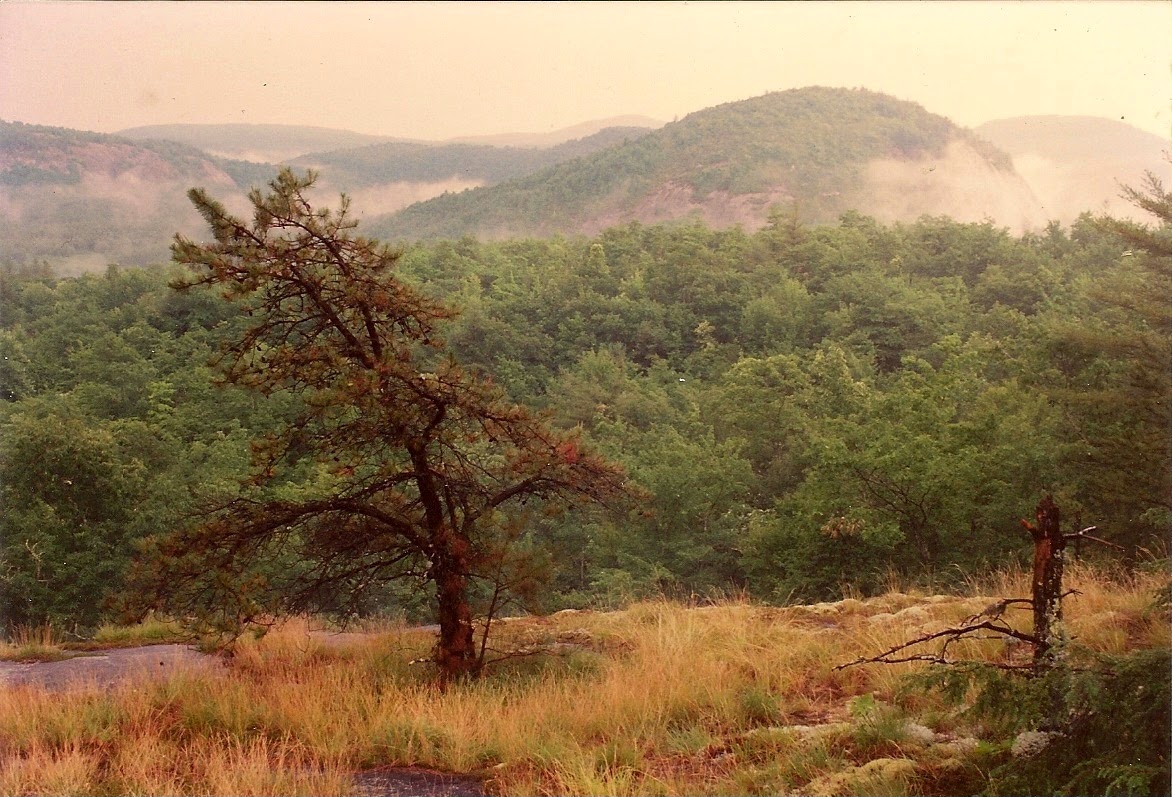
Salt Rock Vista
I first went to Panthertown Valley in the Summer of 1993. I had been wanting to go for 13 years, since the Summer of 1980 when I was a caretaker for the Clarke family on their property at Rock Bridge. Their land bordered Panthertown, and they told me how beautiful it was. This was before the power-line, when the Valley was owned by Liberty Life Insurance Co, and not open to the public. Then Duke Energy bought the property and did their abomination.
Then finally some good news; Mr. Clarke, who was a US Congressman at the time, was very instrumental in arranging the purchase of the remnants of Panthertown Valley by the Nature Conservancy, and then its transfer to the National Forest. It could have become just one more gated "community" with mansions hanging off the cliffs. I'm grateful that so much was saved!
I procrastinated a few years longer, but finally decided I had to go. I got a shiny new topo map and driving directions to Salt Rock Gap, and drove out on a Summer Saturday morning. (Breedlove Rd was all gravel at that time which made the drive more interesting!) I got parked at the trailhead and headed off down the road. I signed the entry log book on a tree beside the trail. (Is that still there?)
Of course it wasn't long before I came to Salt Rock, and I was just overwhelmed. The valley was so beautiful, and looked like hiker heaven. That view was worth the drive! I walked on down to the crossroads at the bottom of the hill and randomly took the right hand turn onto what is now known as the Mac's Gap trail. You need to remember that back then none of the trails were named, marked, or blazed. Only a few of the main logging roads were on my topo map, unnamed.
I soon came to what I call Pine Valley:

Evidently after that area was clear-cut it was replanted in White Pine. I heard someone planted them for Christmas trees but never cut them. (Does anybody know anything about that? Does anybody raise White Pine for Christmas trees?) However they got there it's a magical place. The open park-like spaces covered in pine needles, the ferns & moss, very cool!
I followed the road and after a while it started up the mountain. I went up for a while, but finally turned around because I didn't want to wear myself out on hills without knowing if they went anywhere worthwhile. (Shows how little I knew!) I backtracked through Pine Valley, still enjoying the unique look and feel of those woods.
I can't remember for sure, but I think I probably discovered Granny Burrell Falls (at low water flow) along the way:

I never could pass a side-trail without checking it out. After all, it might go somewhere! So I'm going to give myself that much credit.
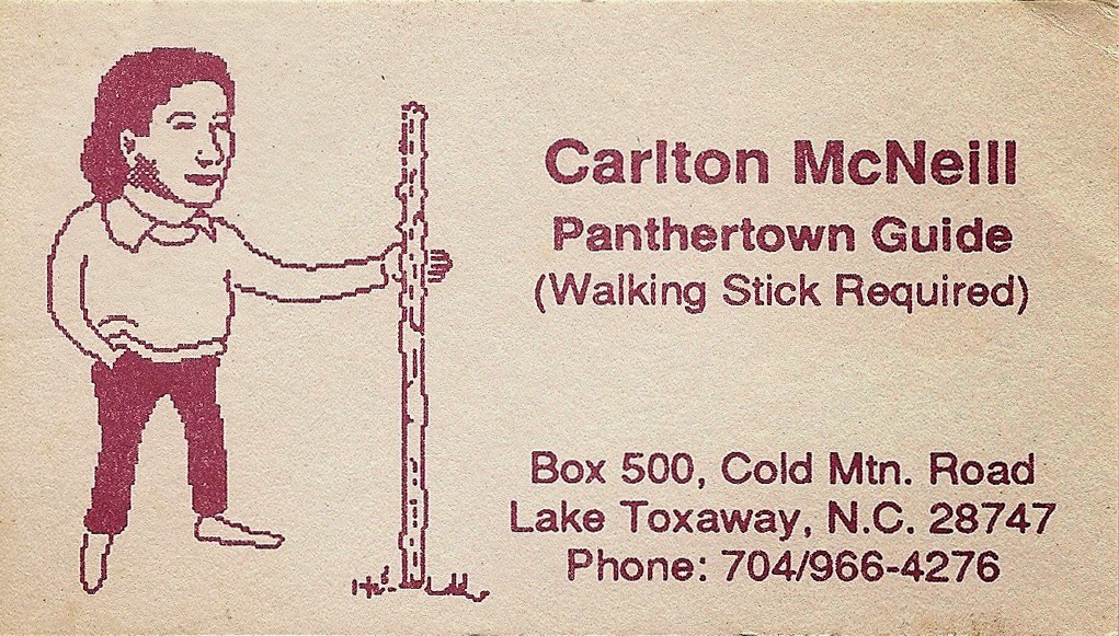
Back at the crossroads I turned right and headed down the Panthertown Valley trail. I passed the Sandbar Pool with its little shelter, and when I came to the old rickety bridge over Panthertown Creek (Since replaced I believe) I decided it was a good place to sit down & eat lunch & try to figure out where I was and where to go next. So I was sitting on the middle of the bridge dangling my feet over the creek when this old guy & his dog came along. He said his name was Carlton McNeill, his dog was Cheyenne, and he was the unofficial guide to the Valley. He talked like an old codger, but you could tell there was more to him than that.

It's hard to describe Carlton, he was a genuinely unique man. He was small built and wiry.
Weather-beaten with a twinkle in his eye. He loved to talk, to everyone he met. He could do a 15 minute monolog while speed-walking up any hill in Panthertown. He'd talk about nature (He knew a lot!) anything about Panthertown, the trail he had just clipped out, literature, philosophy. (He was a devout atheist.) I once asked his age and he replied: "Well, I got as far as 70 and figured that was old enough for anybody, so I turned around and started going back the other way. I'm down to 67 now."
He could see I was clueless about Panthertown, so he took my topo map & showed me where I was and with an old pencil sketched in a couple of trails he said I should try. He suggested I should go on from where I was to see School House Falls. He said I could then go up and across Little Green Mt to Mac's Gap trail (Pine Valley again!) and go back out that way. Sounded good to me so I set off refreshed and encouraged. Before I left Carlton gave me his business card and told me to give him a call if I wanted a guided hike.
I found School House Falls and spent some time admiring it.

There was a drought going on, Carlton said it hadn't rained for weeks. Everything was bone dry, and the water flow was way down. But it was still pretty!.
I located the trail up Little Green and made the climb. I came up to what's now known as Tranquility Point and just stood there admiring the view and the surroundings. This was what I had come to see!

But meanwhile I kept hearing rumbles of thunder from the West. I tried to find my way across the clifftop as Carlton had instructed, but couldn't find the path right away. And that thunder kept getting closer. Maybe it hadn't rained for weeks, but now I was here. Standing on top of a cliff. And that storm was getting CLOSE! Time to retreat the way I had come, and quick. I started down the trail and the rain began. Not just a little rain, but a genuine Wrath of God Thunderstorm. Of course I didn't have rain gear, and was soaked in no time. Water was streaming across my glasses, and I could barely see the trail. (Of course I could take them off but really couldn't see then!) I had a case with all my camera gear that I really hoped was waterproof.
I felt my way back down to the valley and made it to the open-sided shelter at the Sandbar Pool.

I went in with 3 or 4 refugees already there and watched the storm. The drought was over for sure! It must have put down 2 or 3 inches in an hour. Rain was blowing in one side of that shelter and out the other. I think I'd have been drier if I'd jumped in the river! Finally it slacked off some, and I decided it was time to go, so I headed up the Panthertown Valley trail. There were long stretches where the water was standing a foot deep in the road, over the top of my boots of course! Just when I thought I couldn't get any wetter...
But I slogged my way through and finally made that last climb to Salt Rock. That's when I took these pictures. The storm was over and mist was hanging in the valleys & swirling around the cliffs.


That experience made the near-drowning seem trivial! I was happy with my day, and knew I'd be back to learn more about this amazing place.
(Some of the other photos on this page were taken on different hikes, but are representative of what I saw that day. I apologize for the image quality, I'm scanning faded old 4x6 prints, but it's what I've got!)
Of course it wasn't long before I came to Salt Rock, and I was just overwhelmed. The valley was so beautiful, and looked like hiker heaven. That view was worth the drive! I walked on down to the crossroads at the bottom of the hill and randomly took the right hand turn onto what is now known as the Mac's Gap trail. You need to remember that back then none of the trails were named, marked, or blazed. Only a few of the main logging roads were on my topo map, unnamed.
I soon came to what I call Pine Valley:
Evidently after that area was clear-cut it was replanted in White Pine. I heard someone planted them for Christmas trees but never cut them. (Does anybody know anything about that? Does anybody raise White Pine for Christmas trees?) However they got there it's a magical place. The open park-like spaces covered in pine needles, the ferns & moss, very cool!
I followed the road and after a while it started up the mountain. I went up for a while, but finally turned around because I didn't want to wear myself out on hills without knowing if they went anywhere worthwhile. (Shows how little I knew!) I backtracked through Pine Valley, still enjoying the unique look and feel of those woods.
I can't remember for sure, but I think I probably discovered Granny Burrell Falls (at low water flow) along the way:
I never could pass a side-trail without checking it out. After all, it might go somewhere! So I'm going to give myself that much credit.
Back at the crossroads I turned right and headed down the Panthertown Valley trail. I passed the Sandbar Pool with its little shelter, and when I came to the old rickety bridge over Panthertown Creek (Since replaced I believe) I decided it was a good place to sit down & eat lunch & try to figure out where I was and where to go next. So I was sitting on the middle of the bridge dangling my feet over the creek when this old guy & his dog came along. He said his name was Carlton McNeill, his dog was Cheyenne, and he was the unofficial guide to the Valley. He talked like an old codger, but you could tell there was more to him than that.
It's hard to describe Carlton, he was a genuinely unique man. He was small built and wiry.
Weather-beaten with a twinkle in his eye. He loved to talk, to everyone he met. He could do a 15 minute monolog while speed-walking up any hill in Panthertown. He'd talk about nature (He knew a lot!) anything about Panthertown, the trail he had just clipped out, literature, philosophy. (He was a devout atheist.) I once asked his age and he replied: "Well, I got as far as 70 and figured that was old enough for anybody, so I turned around and started going back the other way. I'm down to 67 now."
He could see I was clueless about Panthertown, so he took my topo map & showed me where I was and with an old pencil sketched in a couple of trails he said I should try. He suggested I should go on from where I was to see School House Falls. He said I could then go up and across Little Green Mt to Mac's Gap trail (Pine Valley again!) and go back out that way. Sounded good to me so I set off refreshed and encouraged. Before I left Carlton gave me his business card and told me to give him a call if I wanted a guided hike.
I found School House Falls and spent some time admiring it.
There was a drought going on, Carlton said it hadn't rained for weeks. Everything was bone dry, and the water flow was way down. But it was still pretty!.
I located the trail up Little Green and made the climb. I came up to what's now known as Tranquility Point and just stood there admiring the view and the surroundings. This was what I had come to see!
But meanwhile I kept hearing rumbles of thunder from the West. I tried to find my way across the clifftop as Carlton had instructed, but couldn't find the path right away. And that thunder kept getting closer. Maybe it hadn't rained for weeks, but now I was here. Standing on top of a cliff. And that storm was getting CLOSE! Time to retreat the way I had come, and quick. I started down the trail and the rain began. Not just a little rain, but a genuine Wrath of God Thunderstorm. Of course I didn't have rain gear, and was soaked in no time. Water was streaming across my glasses, and I could barely see the trail. (Of course I could take them off but really couldn't see then!) I had a case with all my camera gear that I really hoped was waterproof.
I felt my way back down to the valley and made it to the open-sided shelter at the Sandbar Pool.
I went in with 3 or 4 refugees already there and watched the storm. The drought was over for sure! It must have put down 2 or 3 inches in an hour. Rain was blowing in one side of that shelter and out the other. I think I'd have been drier if I'd jumped in the river! Finally it slacked off some, and I decided it was time to go, so I headed up the Panthertown Valley trail. There were long stretches where the water was standing a foot deep in the road, over the top of my boots of course! Just when I thought I couldn't get any wetter...
But I slogged my way through and finally made that last climb to Salt Rock. That's when I took these pictures. The storm was over and mist was hanging in the valleys & swirling around the cliffs.
That experience made the near-drowning seem trivial! I was happy with my day, and knew I'd be back to learn more about this amazing place.
(Some of the other photos on this page were taken on different hikes, but are representative of what I saw that day. I apologize for the image quality, I'm scanning faded old 4x6 prints, but it's what I've got!)
No comments:
Post a Comment